Last week I shared with you my experience climbing a mountain for a trail of about 19 kilometers (to go and return) to the top where I found a beautiful lagoon out of a book of expeditions, virgin nature and remote times. However, it's not the only time I've done a trail like this and it's not the only lagoon or lake I've visited, so today I want to share with you another similar experience but with important differences that I had some months after the previous one.
La semana pasada les compartí mi experiencia subiendo una montaña durante un sendero de unos 19 kilómetros (para ir y volver) hasta la cima en donde me encontré con una hermosa laguna sacada de un libro de expediciones, naturaleza virgen y tiempos remotos. Sin embargo, no es la única vez que he hecho un sendero así y no es la única laguna o lago que he visitado, así que hoy quiero compartirles otra experiencia similar pero con importantes diferencias que tuve algunos meses después de la anterior.
Previously, some decades ago, the Regions of Chile were named by their number. That is, we used to talk about the X Region or the V Region (always in Roman numerals), but some time ago there was a national campaign to get people used to call them by their name, such as the Metropolitan Region, or the Valparaíso Region, etc. Well, there are two regions of Chile (states, counties, whatever you want to call them) called Región de Los Lagos (Lagos is Lakes) and Región de Los Ríos (Ríos means Rivers), which may give you an idea of the large amount of bodies of water in the south of Chile. There is a famous circuit called Circuito de los 7 Lagos and a lot of activities and events around these lakes, lagoons, rivers, mountains and volcanoes that blend into the landscape in an unusual way in the world, but quite familiar in the country. Think that in Chile there are more than eighty volcanoes, dozens of lakes, hundreds of rivers... it's easy, in the south, to find a landscape that mixes several of these attractions and on a trip I made to Puerto Varas I was able to get to the vicinity of the Vicente Perez Rosales National Park, on the other side of Lake Llanquihue, where the famous Lake of All Saints is located. From the base you can only see a large expanse of water, but it's difficult to size it and the truth is that being there at that level, the lake is a body of water surrounded by mountains that doesn't seem to present greater attraction. But from the heights it's another thing and as I am fond of high views I wanted to do a mountain trekking to see the lake from above.
Anteriormente, hace algunas décadas, las Regiones de Chile eran nombradas por su número. Es decir, se hablaba de la X Región o de la V Región (siempre en números romanos), pero hace algún tiempo se hizo una campaña nacional para que las personas se acostumbrasen a llamarlas por su nombre, tales como la Región Metropolitana, o la Región de Valparaíso, etc. Bueno, hay dos regiones de Chile (estados, condados, como les quieran llamar) que se llaman Región de Los Lagos y Región de Los Ríos, lo que les puede dar una idea de la gran cantidad de cuerpos de agua que hay al Sur de Chile. Hay un famoso circuito que se llama Circuito de los 7 Lagos y un montón de actividades y convocatorias alrededor de estos lagos, lagunas, ríos, montañas y volcanes que se mezclan en el paisaje de una manera poco común en el mundo, pero bastante familiar en el país. Piensen que en Chile hay más de ochenta volcanes, decenas de lagos, centenares de ríos... es fácil, en el Sur, encontrarse con un paisaje que mezcle varios de estos atractivos y en un viaje que hice a Puerto Varas pude llegar a las cercanías del Parque Nacional Vicente Pérez Rosales, al otro lado del Lago Llanquihue, en donde se encuentra el famoso Lago de Todos Los Santos. Desde la base sólo se ve una gran extensión de agua, pero es difícil dimensionarlo y la verdad es que estando allí a ese nivel, el lago es un cuerpo de agua cercado por montañas que no pareciera presentar mayor atractivo. Pero desde las alturas es otra cosa y aficionado como soy a las vistas altas quise hacer un trekking de montaña para poder ver el lago desde lo más alto posible.
When I entered the park, after registering, they told me which were the different trails and how much time I would need to do each one. I can't remember the name of the trail I did, but there was one whose name seemed curious to me, Sendero Desolación (Desolation Path), which was 12 kilometers, one way. Due to time constraints, I couldn't do that one (although I don't know if I would have done it with that name), but I did one of about 7 or 8 kilometers and about 700 meters of elevation gain.
Al ingresar al parque, después de registrarme, me indicaron cuáles eran los distintos senderos y cuánto tiempo necesitaría para hacer cada uno. No logro recordar el nombre del sendero que hice, pero había uno cuyo nombre me pareció curioso, Sendero Desolación, que tenía 12 Kilómetros, sólo de ida. Por temas de tiempo, no podía hacer ese (aunque no sé si lo hubiera hecho con ese nombre que tiene), pero hice uno de aproximadamente unos 7 u 8 kilómetros y unos 700 metros de desnivel aproximadamente.
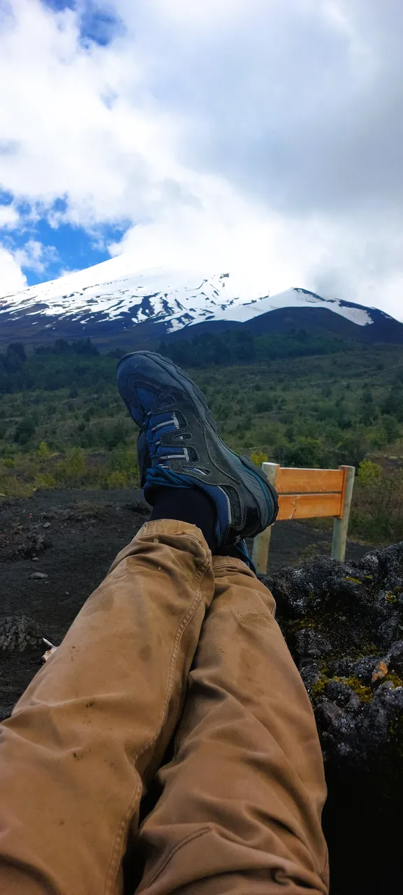
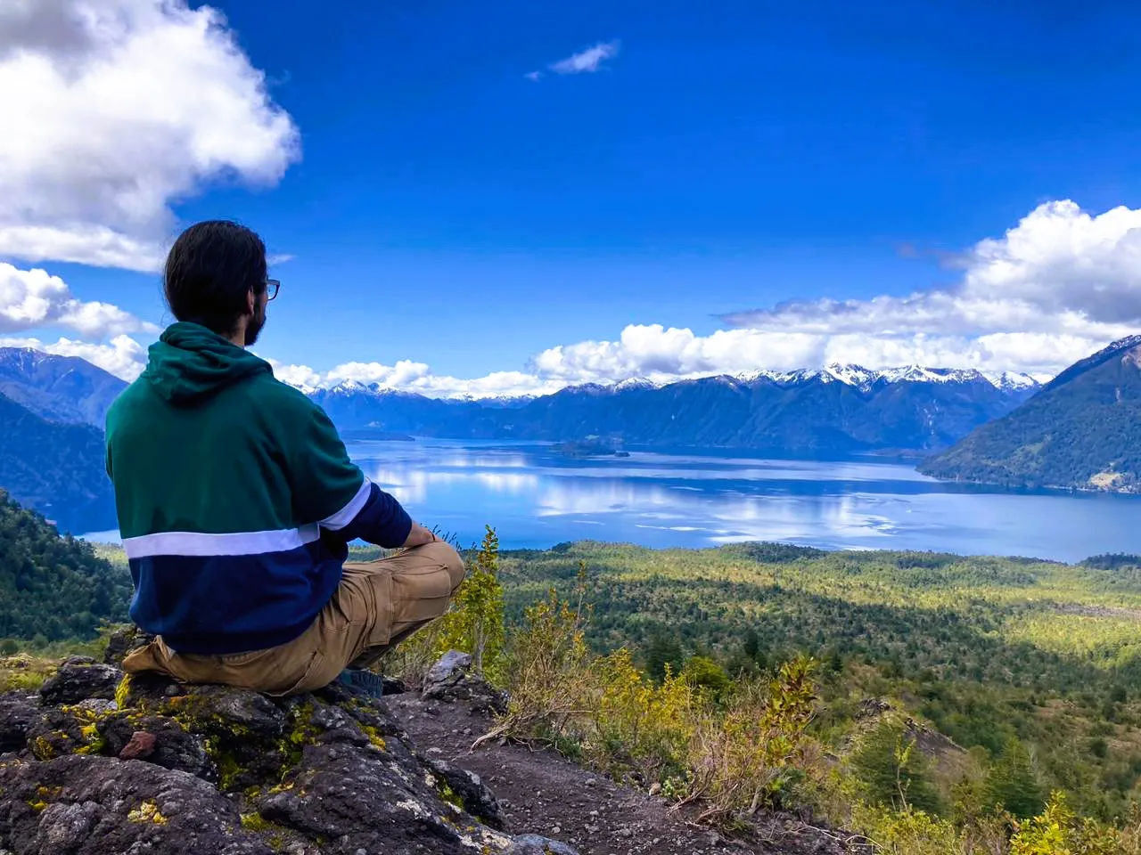
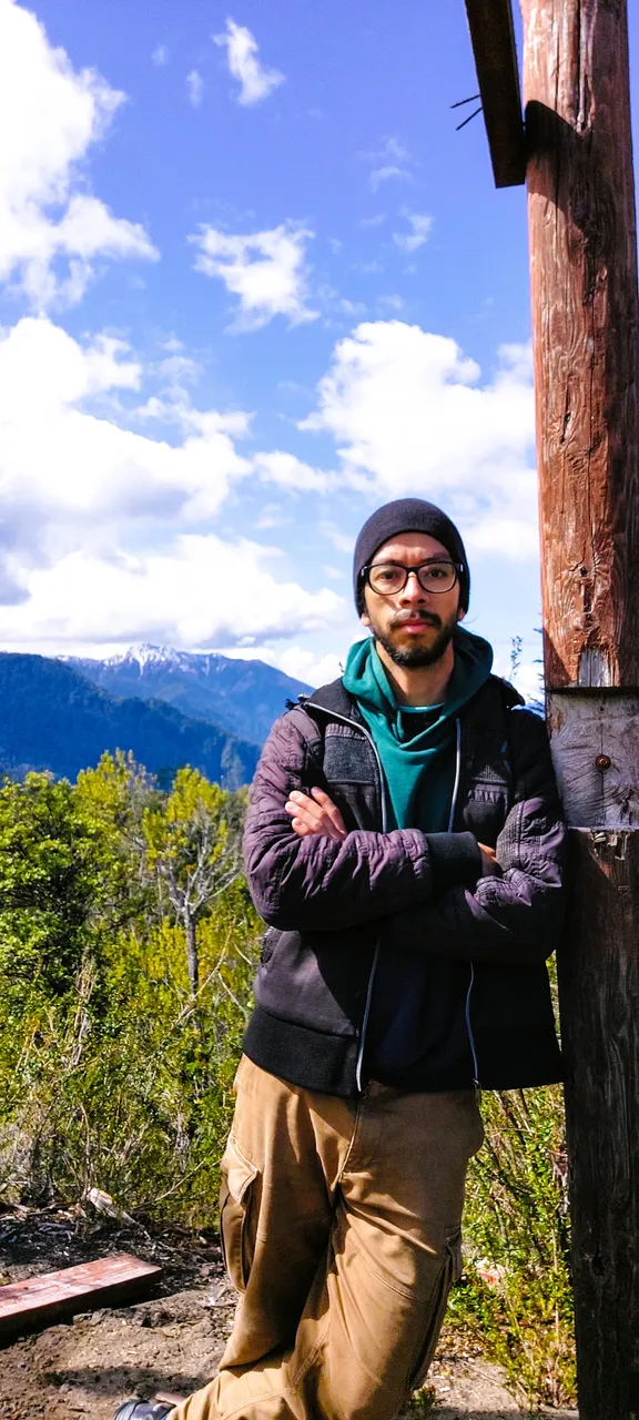
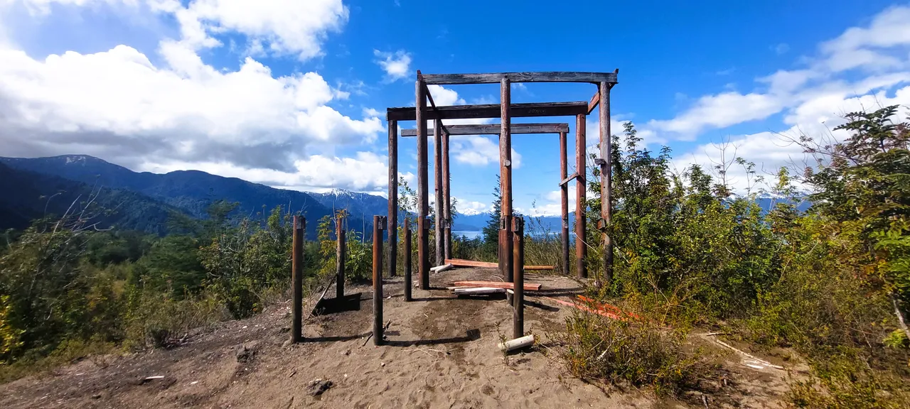
As I went in early spring, the thaw had not yet begun, but it was not so cold. That, plus a beautiful clear blue sky allowed me to observe the landscape during the ascent and notice how on the road I could see the riverbed, the path where the water would come down once the snow melted in the mountains. The ascent didn't feel so steep at the beginning, but as I approached the “Mirador La Picada”, the climb started to get steeper. At one point along the way I noticed the remains of a wooden structure and approached it. That's another of my hobbies: ruins. I really like the idea of visiting an abandoned house, the remains of some construction destroyed by time, no matter how small, those vestiges of history, what is left of something that was gives me a curious feeling and when I saw these timbers I approached. I couldn't tell exactly what it had been, but judging by the layout and location, it may have once been some kind of lookout or rest hut for hikers. It didn't look that old really, but I think it had been quite a while since it was complete because there wasn't much debris to be seen around except for some boards and logs. I don't know what it would take to recover or repair it, but I think a lookout in that spot would look amazing. A little further up, when I reached the viewpoint, I could rest at the foot of the Osorno Volcano, one of the most beautiful in Chile, but once I stopped looking at the majesty of the volcano and allowed myself to turn my eyes, I found the beautiful scenery of the lake, now from above:
Como fui a inicios de la primavera, aún no había comenzado el deshielo, pero ya no había tanto frío. Eso, sumado a un cielo azul hermoso y despejado me permitió observar el paisaje durante el ascenso y notar cómo en la vía se podía ver el cauce, la vía por donde bajaría el agua una vez que se derritiera la nieve en las montañas. El ascenso no se sintió tan inclinado al inicio, pero conforme me acercaba al "Mirador La Picada", la subida se comenzó a poner más fuerte. En un punto del camino noté los restos de una estructura de madera y me acerqué. Esa es otra de mis aficiones: las ruinas. Me gusta mucho la idea de visitar una casa abandonada, los restos de alguna construcción destruida por el tiempo, por pequeña que sea, esos vestigios de historia, lo que queda de algo que fue me produce una sensación curiosa y al ver estos maderos me acerqué. No pude saber exactamente qué había sido, pero a juzgar por la distribución y por la ubicación, es posible que haya sido en otro momento algún tipo de mirador o de caseta de descanso para los senderistas. No se veía tan antigua de verdad, pero creo que ya había pasado bastante tiempo desde que estuviera completa porque no se veían muchos restos por los alrededores, salvo algunas tablas y troncos. No sé qué se necesite para recuperarla o repararla, pero creo que un mirador en ese spot quedaría increíble. Un poco más arriba, cuando llegué al mirador habilitado, pude reposar a los pies del Volcán Osorno, uno de los más bonitos de Chile, pero una vez que dejé de mirar la majestuosidad del volcán y me permití girar la vista, me encontré con el hermoso paisaje del lago, ahora desde lo alto:
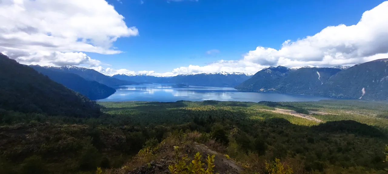
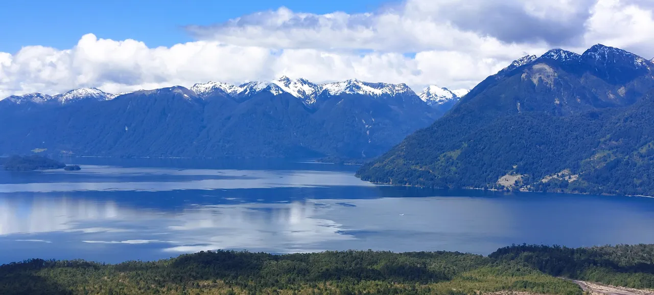
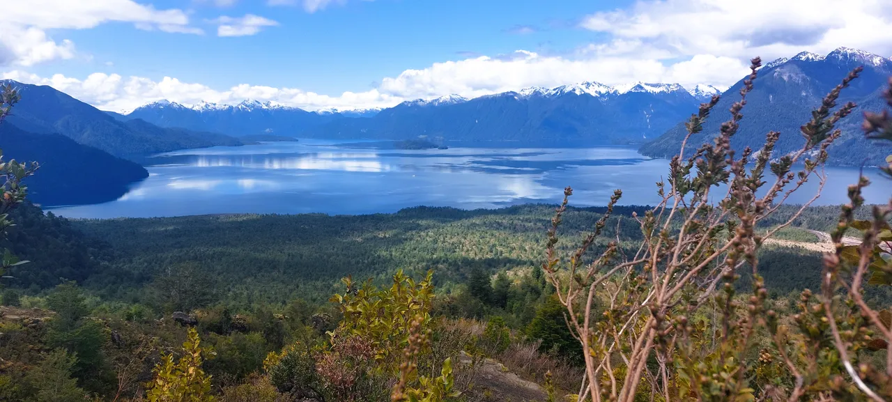
The whole landscape was a spectacle of green and blue tones (coincidentally my sweatshirt had the same colors), but the most impressive thing about being in that place was the tranquility and silence. The only thing you could hear was the wind, there was no other sound that disturbed the peace of the place. It was enough to stay there for hours and hours, meditating, reading, or simply enjoying the magic of nature. So if you come to southern Chile, near Puerto Varas or Puerto Montt, I recommend a tour in which you can see two attractions for the price of one, the Petrohué River falls and the Lake of All Saints, both located within the Vicente Perez Rosales National Park, do you know them? would you like to come? I'll read you in the comments.
Todo el paisaje era un espectáculo de tonos verdes y azules (casualmente mi sudadera tenía los mismos colores), pero lo más impresionante de estar en ese lugar era la tranquilidad y el silencio. Lo único que se oía era el viento, no había ningún otro sonido que perturbara la paz del lugar. Como para quedarse horas y horas allí, meditando, leyendo, o sencillamente disfrutando de la magia de la naturaleza. Así que si vienen al Sur de Chile, cerca de Puerto varas o Puerto Montt, les recomiendo un paseo en el que pueden ver dos atractivos por el precio de uno, los saltos del Río Petrohué y el Lago de Todos los Santos, ambos ubicados dentro del Parque Nacional Vicente Pérez Rosales, ¿los conocen? ¿les gustaría venir? Los leo en los comentarios.
Text and Pictures: | Texto e imágenes:
Other posts that may interest you | Otros posts que pueden interesarte:
 |
|---|