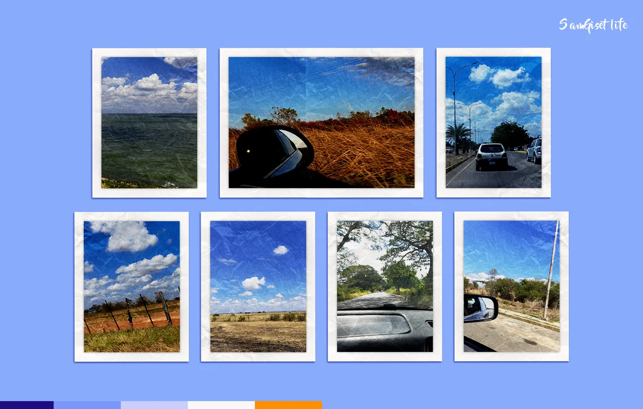
Oh yes, I love road trips because they allow me to live other visual experiences, the landscapes, to see how they change in their shapes and colors is majestic, even more when you know that these landscapes are building the road home. In today's post I will share with you some of the landscapes that we visualized traveling from El Tigre Venezuela to Calabozo Guárico State in Venezuela.
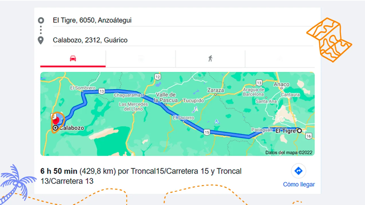
This is how the route looks like in this Google Maps image, it is a journey of approximately 6 hours 50 minutes, as the road is not in optimal conditions it makes it much slower the arrival time, however the experts who drive daily on this route can arrive in less time.
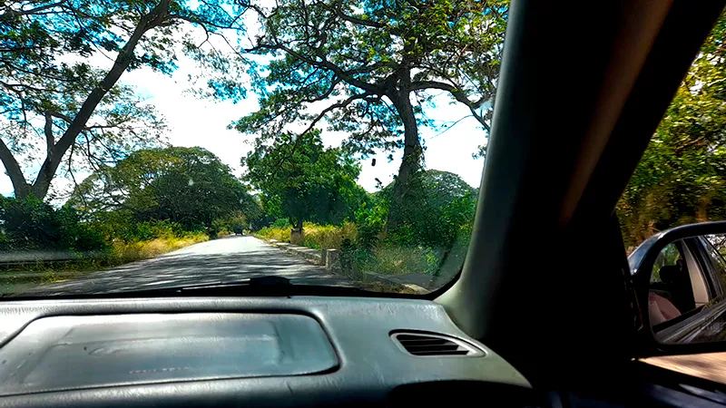
From the moment we leave the city of El Tigre we begin to see changes in the vegetation, this area is cooler, so everything here is greener, as we approach the State of Guárico the vegetation becomes more yellow, this happens in the summer season, when it is winter everything is very green and beautiful.

L A N D S C A P E S

This area is full of plains, in fact El Tigre Venezuela is part of the eastern plains, it is an area of plains, while Guárico Venezuela is a state that belongs to the central plains of the country. So the landscapes are full of views with a deep horizon.
Guárico is an agricultural state, so it is common to see farms, corn and sorghum plantations and in cities such as Calabozo there is abundant rice production. 🙂
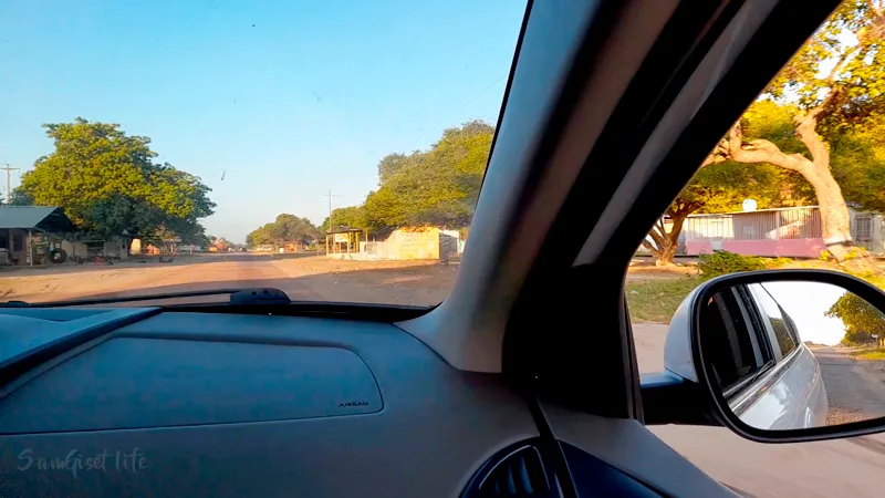
Also in this distance of 429 kilometers it is common to find small villages and towns that make the road feel much shorter. In the small towns, most of the buildings are simple and the inhabitants offer sales to the public such as bread, ice cream, coffee, typical sweets and other local products that may be attractive to travelers.
M O R E - L A N D S C A P E S
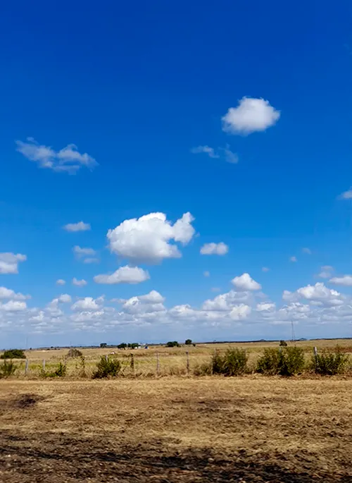
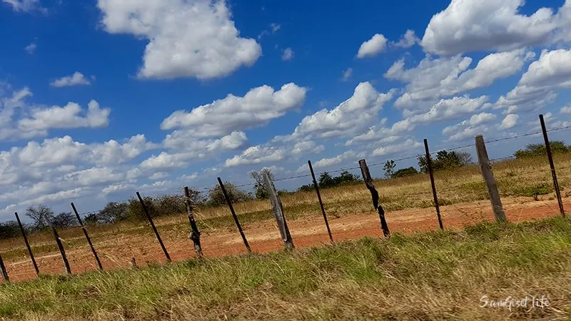
This is a typical llanero landscape, although it looks very small there were some cows eating in these pastures, the sky is clear and there are few trees that give shade, although it seems somewhat deserted this is a product of agricultural activity, in the rainy season it is very likely that this area is much more populated with grass. It looks like a planned planting for this type of livestock.
I don't visit my family often but when I do, I enjoy these beautiful landscapes, especially if the day is sunny and lets us enjoy the blue sky.
There is a place that is like a fixed stop, it is a small town and it is called El Sombrero, in this place there are places to sell food, access to bathrooms, there are fueling stations, car repair shops, sales of agricultural products and more.
El Sombrero is part of the State of Guárico, it is characterized by its high production of onion and tomato, in some opportunities when I am returning I have bought these products, since eventually they can be much cheaper than here where I live.
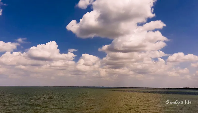
After many hours of highway and flat landscapes, depending on the road you choose you may enter Calabozo Guárico passing over the bridge of its dam, the Generoso Campilongo dam; this reservoir is one of the best things that my hometown has, especially because it allows agricultural production activities to be carried out through irrigation systems.
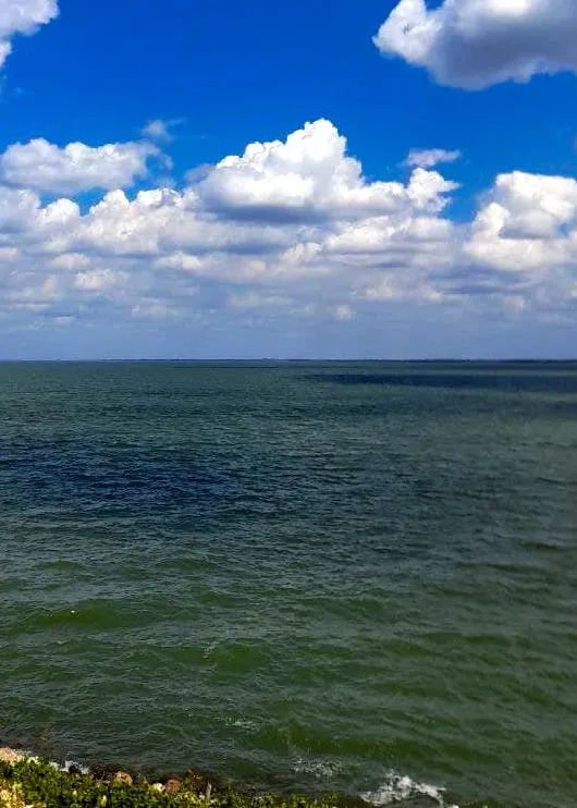
For many minutes it is this landscape that is reflected in our eyes, the waters of the dam and the beautiful blue sky. This dam has a frontal spillway, controlled by radial gates. Some of these gates are located at the entrance of the city of Calabozo, in fact when they are released it is an attraction to see the water running at high speed.
The area near the gates of the Guárico dam are very careful, it is forbidden to bathe in these waters.
In this way we close this beautiful tour, there is much more we can see, but this is a summary of some natural landscapes that we can enjoy on this road trip. If you do not know Venezuela, today you have had a little of its plains landscapes.
Español
Oh si, los viajes de carretera me encantan porque me permiten vivir otras experiencias visuales, los paisajes, ver como van cambiando en sus formas y colores es majestuoso, más aún cuando sabes que esos paisajes van construyendo el camino a casa. En este post de hoy les compartiré algunos de los paisajes que visualizamos viajando desde El Tigre Venezuela hasta Calabozo Estado Guárico en Venezuela.
Así se ve la ruta en esta imagen de Google Maps, es un trayecto de aproximadamente 6 horas 50 minutos, como la carretera no se encuentra en condiciones optimas hace que sea mucho más lento el tiempo de llegada, sin embargo los expertos que manejan diariamente en esta ruta pueden llegar en menor tiempo.
Desde que salimos de la ciudad de El Tigre empezamos a ver cambios en la vegetación, esta zona es más fresca, así que por acá todo es más verde, a medida que nos acercamos al Estado Guárico la vegetación se hace más amarilla, eso sucede en la época de verano, cuando es invierno todo está muy verde y hermoso.
L A N D S C A P E S
Esta zona está llena de planicies, de hecho El Tigre Venezuela es parte los llanos orientales, es una zona de llanuras, mientras que Guárico Venezuela es un Estado que pertenece a los llanos centrales del país. Así que los paisajes están llenos de vistas con un profundo horizonte.
Guárico es un Estado agrícola, por ello es común ver granjas, siembras de maíz, sorgo y en ciudades como Calabozo donde existe abundante producción de arroz.
También en esta distancia de 429 kilómetros es común encontrar pequeños poblados y ciudades que hacen sentir que el camino es mucho más corto. En los pueblos pequeños la mayoría de las construcciones son sencillas y sus habitantes ofrecen ventas al publico como pan, helados, café, dulces típicos y otros productos locales que pueden ser atractivos para los viajeros.
M O R E - L A N D S C A P E S
Este es un típico paisaje llanero, aunque se ven muy pequeñas habían unas vacas comiendo en estos pastizales, el cielo está despejado y hay pocos árboles que den sombra, aunque parece algo desértico esto es producto de la actividad agrícola, en época de lluvia es muy probable que esta zona esté mucho más poblada de pasto. Parece como una siembra planificada para este tipo de ganado.
No visito a mi familia frecuentemente pero cuando lo hago, aprovecho disfrutar estas bellezas de paisajes, sobre todo si el día está soleado y nos deja disfrutar el azul del cielo.
Hay un lugar que es como una parada fija, es un pequeño pueblo y se llama El Sombrero, en este sitio existen locales de venta de comidas, acceso a baños, hay bombas para recargar combustible, talleres de reparación de autos, ventas de productos agrícolas y más.
El Sombrero es parte del Estado Guárico, se caracteriza por su alta producción de cebolla y tomate, en algunas oportunidades cuando estoy regresando he comprado de estos productos, ya que eventualmente pueden estar mucho más económicos que acá donde vivo.
Después de muchos horas de carretera y paisajes planos, según la vía que elijas es posible que ingreses a Calabozo Guárico pasando sobre el puente de su represa, la represa Generoso Campilongo; este embalse es una de las mejores cosas que posee mi pueblo natal, sobre todo porque permite que se ejecute la actividad de producción agrícola a través de sistemas de riego.
Durante muchos minutos es este paisaje el que se refleja en nuestros ojos, las aguas de la represa y el hermoso azul del cielo. Esta represa tiene un aliviadero frontal, controlado con compuertas radiales. Algunas de estas compuertas se encuentran en la entrada de la ciudad de Calabozo, de hecho cuando son liberadas es un atractivo ir a ver el agua correr a gran velocidad.
La zona cercana a las compuertas de la represa de Guárico son muy cuidadas, está prohibido bañarse en estas aguas.
De esta forma cerramos este hermoso recorrido, es mucho más lo que podemos ver, pero esto es un resumen de algunos paisajes naturales que podemos disfrutar en este viaje de carretera. Sino conoces Venezuela, hoy has tenido un poco de sus paisajes llaneros.
Fotografías de mi autoría
Traducido con Deepl

Otras redes:
Professional account | 3speak.online| Instagram | Youtube Vlog | Youtube Blockchain