Recently I took a winter vacation to Utah and got to witness some really interesting things on the ground during the two cross-country flights. For those of you who have followed my posts for a while know I love photography, and have a passion for aviation and taking photos out the windows during flights.
When I find something curious on the ground I like to try to investigate what it was when I get back home. So begins the first in a serious of "What in the World is That?" posts I will create tracking down features on the ground that caught my attention.
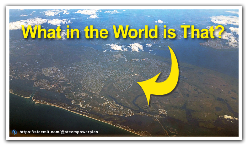
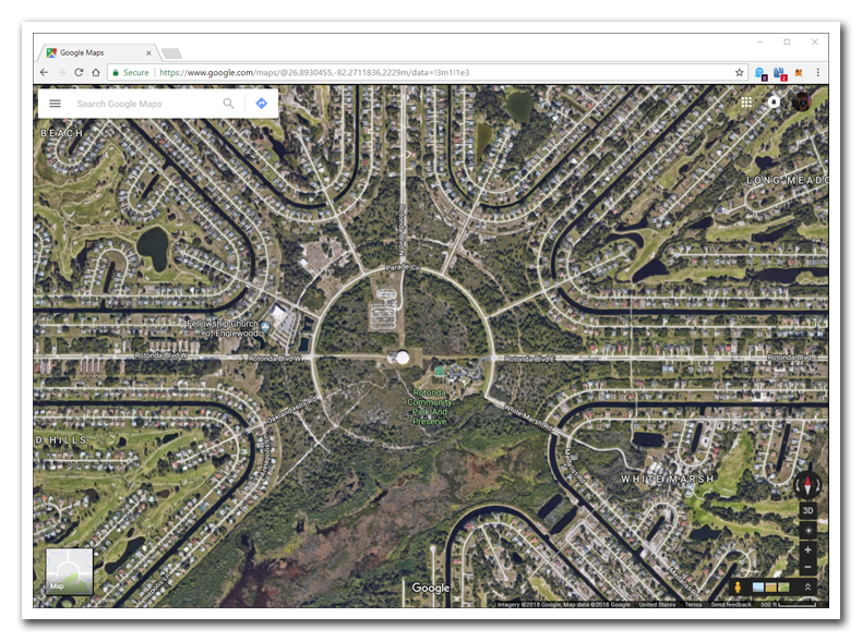
This interesting feature was spotted out the window in the last 30 minutes of our return flight home. Luckily I was on the left side of the plane or I never would have seen this. This perfectly symmetrical pattern of roads and structures reminded me of two things, Palm Island in Dubai, and an old-school airfield.
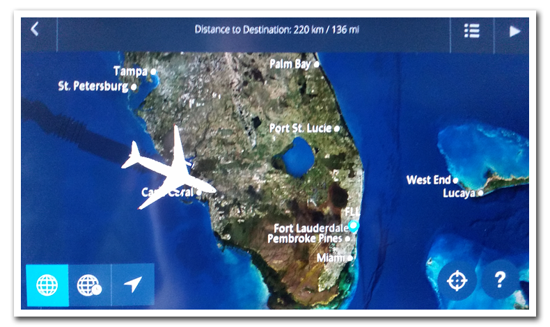
I quickly snapped some pictures, then pulled up the flight map on the in-flight display screen to see roughly where we were as we fly by. This is a super useful tool available to us now, years back I would have to make educated guesses to the general location based on the flight time and its relative location from a recognizable landmark we passed along the way.
With that, I pulled up our favorite "know-it-all" Uncle Google to pin down the location on the map. Given this was a pretty unique feature on the ground it didn't take to long to find.
It was identified as Rotonda West, a community situated in west Charlotte County, Florida. Armed with this information I did some research on the area using wikipedia to learn more about what it was and it's history. What I found out was quite interesting, one of my initial hunches was pretty close.
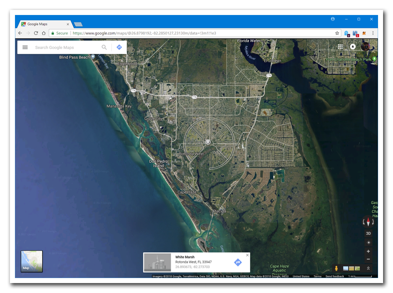
Rotonda West is an unincorporated, deed-restricted community situated in west Charlotte County, Florida, United States. The U.S. Census Bureau lists it as the Rotonda census-designated place, with a population of 8,759 at the 2010 census. It is part of the Punta Gorda Metropolitan Statistical Area. It was developed and named Rotonda West by Cavanagh Communities Corporation, the developers of a projected but now defunct community named Rotonda in southern Martin County and northern Palm Beach County.
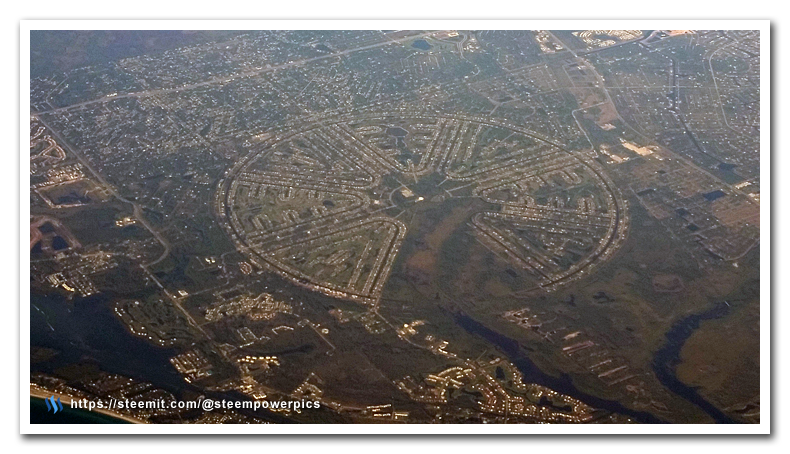
Though the layout of Rotonda West precisely mimics World War 2 airfields in Florida. There was not a similar airport at this location prior to development.
So there it was, the classic "Wagon Wheel" airfield design used in World War II era air bases throughout Florida.
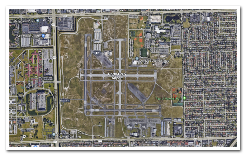
The pattern was familiar to me due to my experience in flight school in the early 90s. I flew out of North Perry Airport in Hollywood, Florida which was originally one of several Naval Air Stations clustered in the South Florida area.
The "wagon wheel" layout of runways allowed for fast launching and recovery of planes in any direction based on the ever-changing wind direction we have down here through the day. In time, all the Naval Air Bases were turned over to the local counties and converted to civilian use.
Roughly 6 miles to the North East of Perry is larger naval installation that is famous for its Bermuda Triangle folklore and the loss of Flight 19 on December 5, 1945. Today it is now Fort Lauderdale/Hollywood International Airport - our final destination on our return flight home.
I hope you enjoyed unraveling the mysterious formation from my vacation travels. I will have another mystery location revealed soon.
Steemit WorldMap
This post has a location marker in it for the @SteemitWorldMap project by @blueorgy and @martibis. By placing a location marker tag in your travel post it will show up on SteemitWorldmap.com
Let me know what you think, please leave your comments below.
As always, please upvote this post and follow me if you like my work and want to see more.
If you think others will enjoy this
Please ReSteem it!
Thanks for reading!