
Image source: My Redmi Note 12 PRO
Hello FreeCompliments community!
Yesterday, a record rainfall (volume of rain in 24 hours) was recorded in my city located in the State of Paraná, Brazil. There was 191 mm of rain according to meteorological stations installed in various parts of the city.
The large volume of water caused several problems, but it is important to clarify that these were not cyclones, tornadoes, or any type of storm. It was just long hours of non-stop rain.
Several municipalities were affected in the micro-region. The vast majority were just waiting for the arrival of the waters, which had already been announced through weather monitoring channels.
The municipality of Francisco Beltrão in particular has an ongoing project that aims to divert part of the volume of water from the river that crosses the city through an underground tunnel.
It is an audacious project and is in the final stages of construction. At least it was, before the current rain episode.
In the image below we see an excavator carrying out an unplanned maneuver, breaking the soil barrier that prevented the river from entering the construction field where excavations were being carried out and reinforcement of the sides of what will become a channel to divert water to the underground tunnel.
The river's natural flow follows to the left, and the excavator "scrapes" the ground allowing the most superficial part of the river to deviate to the right towards the tunnel. At this time, the water bed was already 7 meters high.

Only a small amount of water can be diverted as the canal is still under excavation. It will be 12 meters deep, according to verbal information from the local radio.
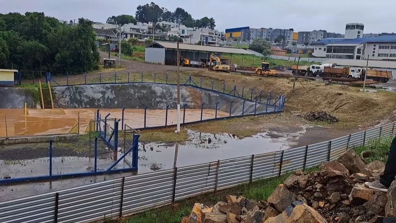
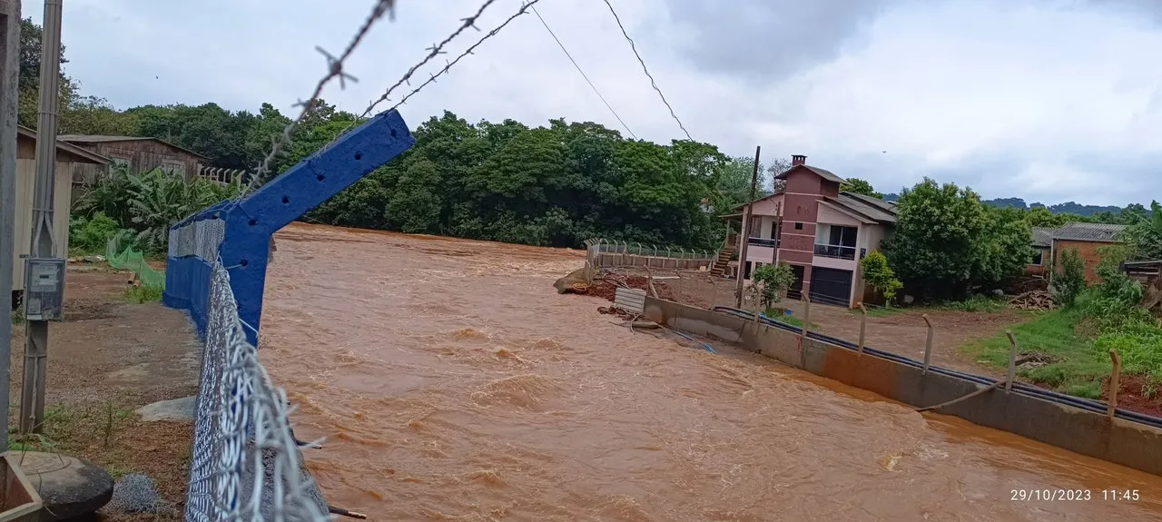
I was personally at the excavation site, which is no longer accessible due to the waters having risen even further. The photo below shows the same location where the excavator used to be. The focal point of the photo shows the place where the small diversion was opened, and the excess water started to flow through the canal being excavated, destroying part of the work that had already been completed, but preventing the water from rising even further.

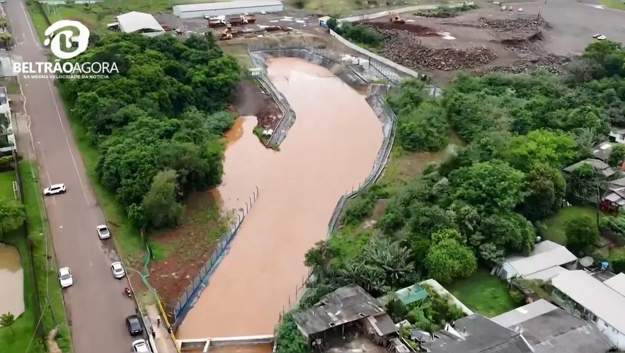
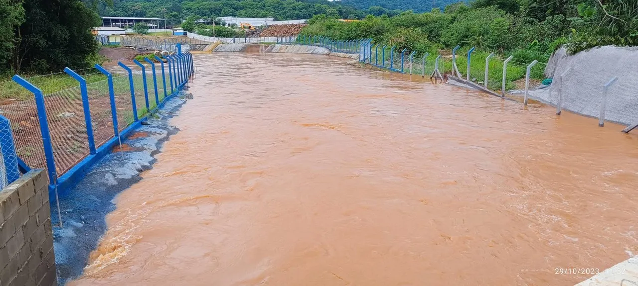
Still in the same region, I took a new photo showing the waters following the flow of the canal towards the underground tunnel. In this location, the canal is already 12 meters deep and you can notice on the right side the concrete applied to stabilize the sides of the work. On the left, the concrete was painted blue, one of the colors of the municipality's flag.

The tunnel is at the end of the photo, in a gentle left turn, it is not possible to approach it for safety reasons. I managed to extract a photo from a video report from a local journalism team.
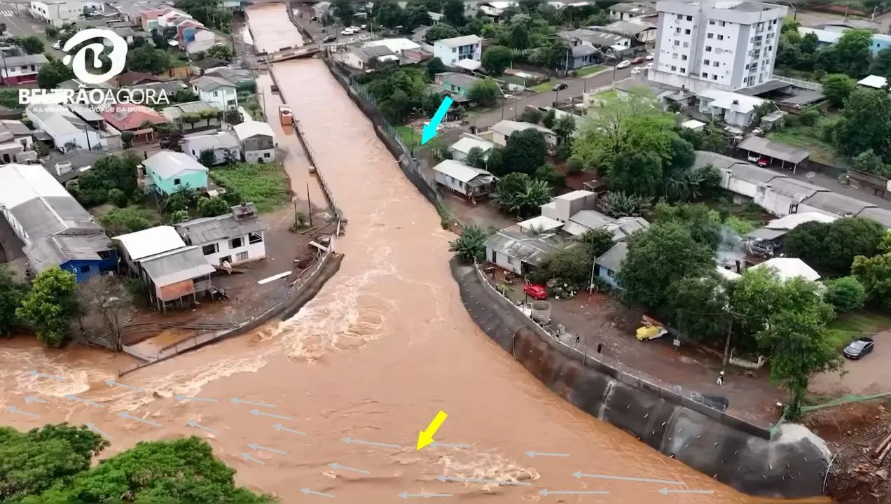
The yellow arrow shows the position of the excavator at the beginning of the post. The gray arrows show the natural flow of the river. The blue arrow shows my location, where I took the images.
The city hall made available a video showing the situation at the mouth of the tunnel, from where I took the image below. The excavator is parked in the background, in case you were worried about it :)
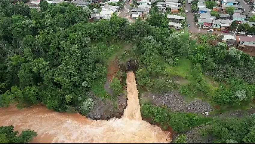
A drone image taken by people shows the situation of the water volume at the entrance to the flood containment tunnel. As it is not possible to see the "mouth" of the tunnel, I was a little worried as I had the impression that it was working at its maximum flow capacity.
Finally, a place that the press is reluctant to publicize, which is the outlet, the end of the tunnel, where it dumps the diverted water back into the riverbed.

The damage in Francisco Beltrão has been minimized thanks to this engineering work that allowed us to face the forces of the waters with a little more hope.
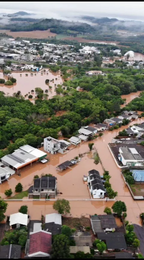
The displaced population and places closed by Civil Defense continue with their usual practices, which are not the intention of this publication. But for the sake of curiosity, the river in question passes through this green strip of trees, but we can see that it has invaded both sides of its bank.

The result of the most audacious engineering work in the region has already freedseveral known flooding sites. However, we cannot forget that on this occasion we had a record amount of rain, and even with the work unfinished we felt hope in the community that we are on the right path.
Let's continue, with hope!
A big hug to everyone!

CrazyPhantomBR supports the FreeCompliments community
I invite you to join the most welcoming community at hive!
10% of funds raised from this post go to @hive-140084
The divider and logo/image belong to CrazyPhantomBR.

CrazyPhantomBR supports Brazilian curation @hive-br
I invite you to discover the curatorial projects of the Brazilian community!
3% of the funds raised in this post go to @hive-br
The divider and logo/image belong to CrazyPhantomBR.
Delegate HP to @hive-br.voter account and earn liquid Hive and the new HBR token daily!
50 HP | 100 HP | 200 HP |500 HP | 1000 HP

Image source: Meu Redmi Note 12 PRO
Olá comunidade FreeCompliments!
No dia de ontem, foi registrado o recorde em precipitação (volume de chuva em 24 horas) na minha cidade localizada no Estado do Paraná, Brasil. Foram 191 mm de chuvas de acordo com as estações meteorológicas instaladas em diversos pontos da cidade.
O grande volume de águas causou diversos transtornos, mas é importante esclarecer que não se tratou de ciclones, tornados, ou qualquer tipo de tempestades. Foram apenas longas horas de chuva sem cessar.
Diversos municípios foram atingidos na microrregião. A grande maioria apenas esperava pela chegada das águas, que já haviam sido anunciadas pelos canais de monitoramento de clima.
O município de Francisco Beltrão em especial possui um projeto em andamento que visa desviar uma parte do volume de água do rio que corta a cidade através de um túnel subterrâneo.
É um projeto audacioso e está em fase final de construção. Ao menos estava, antes do episório de chuvas atual.
Na imagem abaixo vemos uma escavadeira realizando uma manobra não planejada, rompendo a barreira de solo que impedia o rio de adentrar ao campo de obras onde estavam sendo feitas escavações e reforço das laterais do que virá a se tornar um canal para o desvio das águas até o túnel subterrâneo.
O rio tem seu fluxo natural seguindo a esquerda, e a escavadeira "raspa" o terreno permitindo que a parte mais superficial do rio desvie-se para direita em direção ao túnel. Neste momento, o leito das águas já se encontrava a 7 metros de altura.
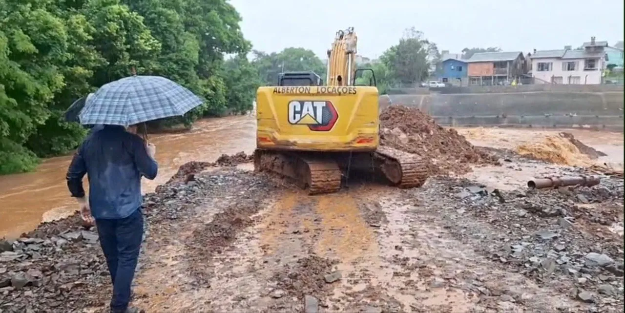
Apenas uma pequena quantidade de água pode ser desviada pois o canal ainda está em fase de escavação. Serão 12 metros de profundidade, conforme informações verbais da rádio local.
Estive pessoalmente no local da escavação, que já não está mais acessível devido as águas terem subido ainda mais. A foto abaixo mostra o mesmo local onde antes estava a escavadeira. O ponto focal da foto mostra o local onde foi aberto o pequeno desvio, e a água excedenta passou a percorrer o canal em escavação, destruindo uma parte do trabalho que já estava concluído, mas impedindo que as águas subissem ainda mais.
Ainda na mesma região, fiz uma novo foto mostrando as águas seguindo pelo fluxo do canal em direção ao túnel subterrâneo. Neste local o canal já possui 12 metros de profundidade e você pode notar na lateral direita o concreto aplicado para estabilizar as laterais da obra. Na esquerda, o concreto foi pintado de azul, uma das cores da bandeira do município.
O túnel está no final do foto, em uma curva suave à esquerda, não é possível se aproximar por motivos de segurança. Consegui extrair uma foto de um vídeo de reportagem de uma equipe de jornalismo local.

A seta amarela mostra a posição onde estava a escavadeira do início da postagem. As setas cinzas mostram o fluxo natural do rio. A seta azul mostra a minha localização, de onde fiz as capturas das imagens.
A prefeitura disponibilizou um vídeo mostrado a situação na boca do túnel, de onde retirei a imagem abaixo. A escavadeira está estacionada ao fundo, caso você estivesse preocupado com ela :)

Uma imagem com drone feita por populares mostra a situação do volume de águas na entrada no túnel de contenção de enchentes. Como não é possível ver a "boca" do túnel, fiquei um pouco preocupado pois tive a impressão que esta trabalhando na sua capacidade máxima de escoamento.
Por fim, um local que a imprensa tem resistência em divulgar, que é o desague, o fim do túnel, onde ele despeja a água desviada devolva ao leito do rio.
Os estragos em Francisco Beltrão está minimizados graças a esse trabalho de engenharia que permitiu enfrentar as forças das águas com um pouco mais de esperança.
A população desalojada e os locais interditados pela Defesa Civil seguem com as práticas de costume, não são a intenção desta publicação. Mas para fins de curiosidade, o rio em questão passa por essa faixa verde de árvores, porém podemos perceber que invadiu ambos os lados de sua margem.
O resultado da obra de engenharia mais audaciosa da região já livrou diversos locais conhecidos de alagamento. Porém, não podemos nos esquecer que nesta oportunidade tivemos um volume recorde de chuva, e mesmo com a obra inacabada sentimos na comunidade a esperança de que estamos no caminho certo.
Sigamos, com esperança!
Um grande abraço a todos!
CrazyPhantomBR apoia a comunidade FreeCompliments
Te convido a ingressar na comunidade mais acolhedora da hive!
10% dos fundos obtidos nesta postagem estão destinados a @hive-140084
O divisor e logotipo / imagem pertencem à CrazyPhantomBR.
CrazyPhantomBR apoia a curadoria brasileira @hive-br
Te convido a conhecer os projetos de curadoria da comunidade brasileira!
3% dos fundos obtidos nesta postagem estão destinados a @hive-br
O divisor e logotipo / imagem pertencem à CrazyPhantomBR.
Delegue HP para conta @hive-br.voter e ganhe Hive líquida e o novo token HBR diariamente!
50 HP | 100 HP | 200 HP |500 HP | 1000 HP